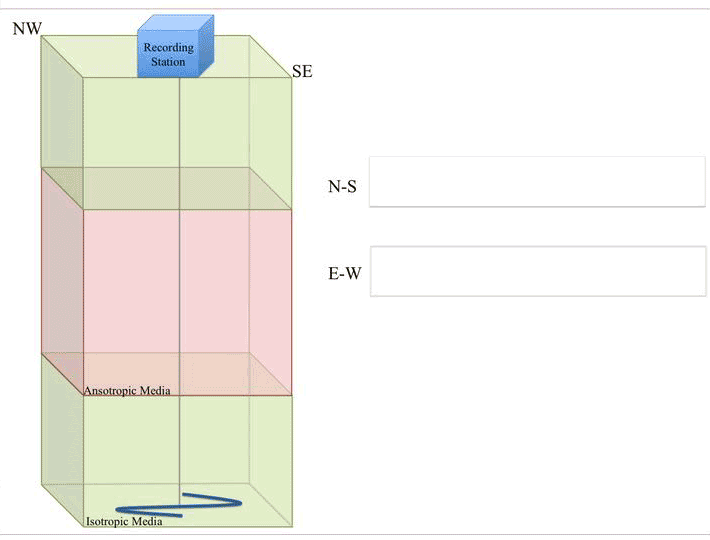
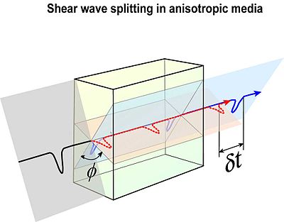
The study of seismic anisotropy has provided useful information for the interpretation and evaluation of the crustal deformation and active stress field (Crampin and Peacock, 2005; Crampin and Gao, 2006;), can yield valuable information on the upper crustal structure, its stress related fracture field, and should be an indicator of the presence of fluid-saturated rocks. Seismic anisotropy is a commonly observed property of the Earth’s crust and is quantifiable by the shear wave splitting. When a seismic shear wave travels through an anisotropic medium, its energy is split into two components with orthogonal polarization directions that travel at different velocities. The polarization direction of the fastest wave is called fast direction (φ) and the lag of the slower wave is the delay time (δt). Seismic anisotropy can yield valuable information on upper crustal structure and fracture field for an improved understanding of the origins of shear wave splitting of the local stress field and of faulting processes active in the area.The study of seismic anisotropy has been applied to exploration geophysics (Crampin and Booth, 1985), to the study of earthquake sources (Zollo and Bernard, 1991; Bouin and Bernard, 1994) and to the definition of an active stress field (De Lorenzo and Trabace, 2011, Pastori et al., 2009; Piccinini et al., 2006; Margheriti et al., 2006, Zinke and Zoback, 2000). Moreover, according to some researchers, monitoring the variation of anisotropic parameters can also contribute to understanding the seismogenic and volcanic processes (Lucente et al., 2010; Unglert et al., 2011) or even to earthquakes forecast (Crampin and Gao, 2010).
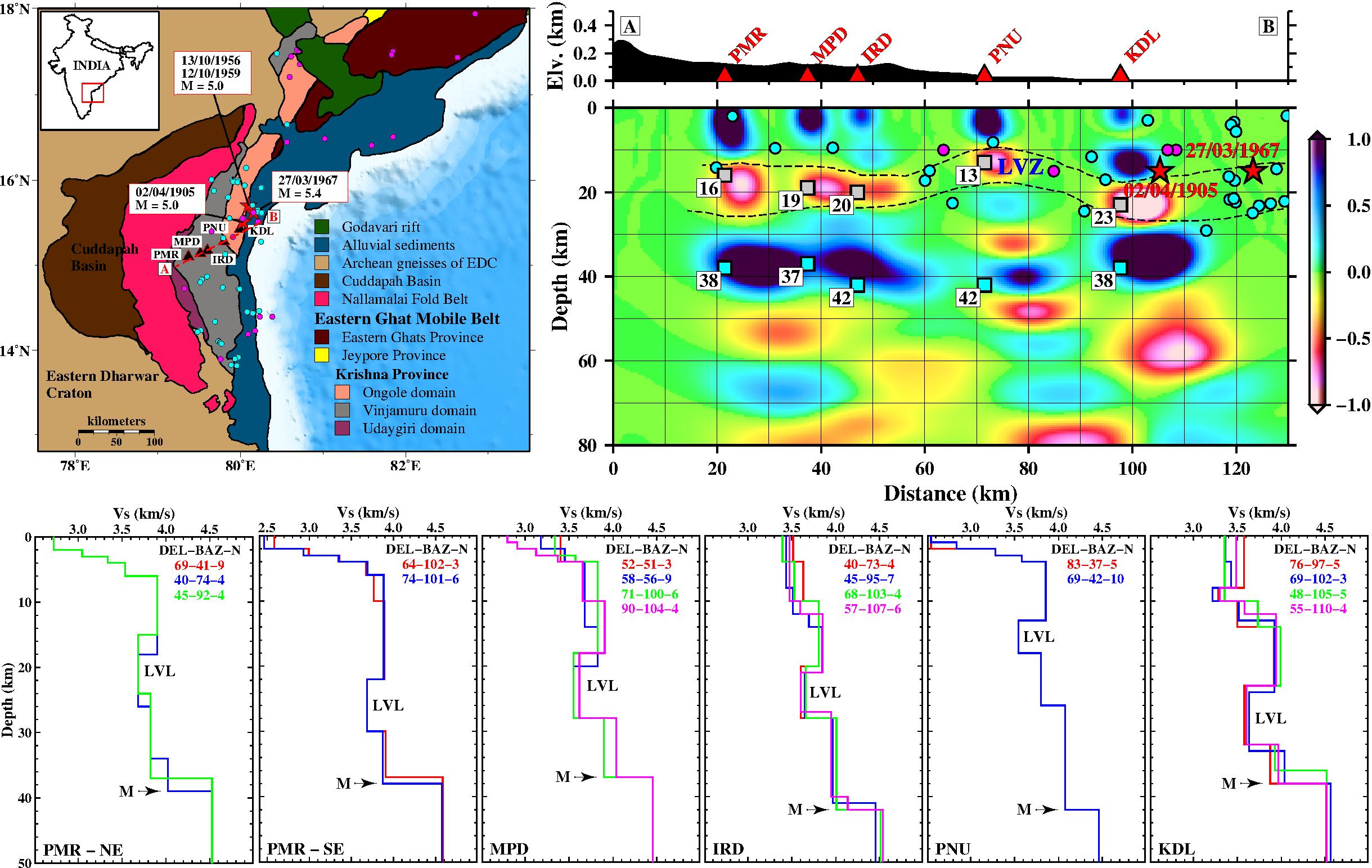
The Eastern Ghat Mobile Belt (EGMB), a tectonically active area extends along the eastern margin of Peninsular India, is divided into three provinces, namely, Eastern Ghat Province, the Jeypore Province, and the Krishna Province. The Ongole domain of Krishna Province is a seismically active region that has experienced four moderate earthquakes of magnitude ≥5.0, of which largest one is of magnitude 5.4 occurred on 27th March 1967. The crustal shear wave velocity structure in the Eastern Ghat Mobile Belt has been investigated using joint inversion of receiver functions and Rayleigh wave group velocity at 5 locations in the study region. The results show crustal thickness variation from 37 to 42 km and average shear velocity variation from 3.67 to 3.78 km/s in the study region. A low velocity layer of variable thickness and velocities (3.67- 3.78 km/s) is also observed in the region. The low velocity layer in most of the stations is observed at a depth of ~20 km. This low velocity layer may be due to the presence of fluid in the crust, which also be one of the causes of the intraplate earthquakes in the study region. (Chaudhuri et al. 2016)
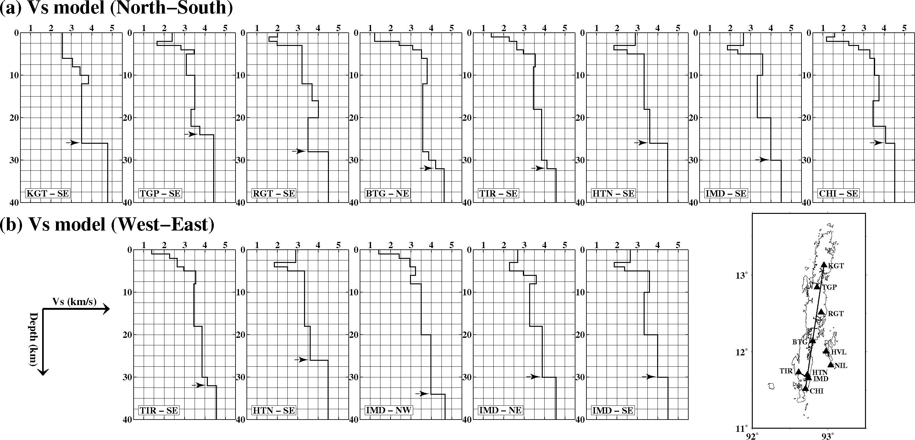
We study shear wave velocity structure of the crust beneath the Andaman Island through joint inversion of the teleseismic receiver function and Rayleigh wave group velocity measurements from 10 broadband seismographs over the Island. The group velocities in the periods from 5 to 21 s are obtained using cross-correlation of six month's ambient seismic noise data recorded by these seismic stations. Joint inversion results show ~2 to 6 km thick subsurface low shear velocity (Vs ~1.3–2.5 km/s) layer followed by a 12–14 km thick layer of silicic material (average Vs ~3.5 km/s). The lower crust is mapped as an 8–12 km thick mafic layer with Vs ~4.0 km/s. Uppermost mantle shear wave velocity is ~4.55 km/s. The near-surface low-velocity layer is interpreted as the Andaman flysch sediments. The crustal thickness beneath the Andaman Island varies from ~24 km in the north to ~32 km in the south. The shear wave velocity-depth results show that the crustal structure beneath the Andaman Island is akin to continental crust, possibly the Burma continental crust. The subducting Indian plate may lie down below this overriding plate. (Gupta et al. 2016)
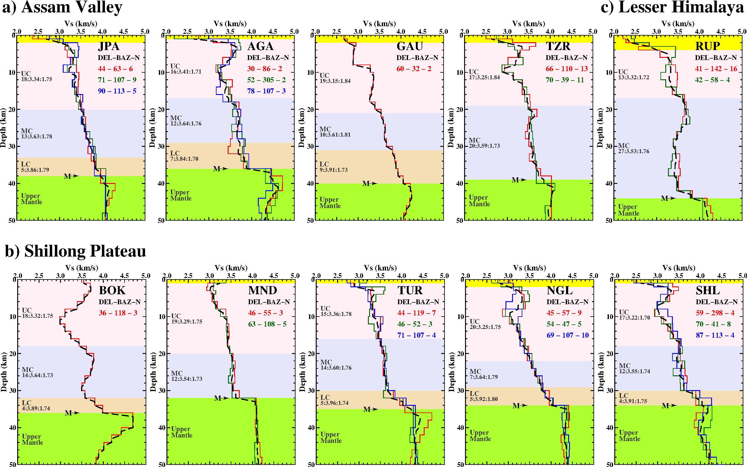
We estimated crustal shear velocity structure beneath ten broadband seismic stations of northeast India, by using H-Vp/Vs stacking method and a non-linear direct search approach, Neighbourhood Algorithm (NA) technique followed by joint inversion of Rayleigh wave group velocity and receiver function, calculated from teleseismic earthquakes data. Results show significant variations of thickness, shear velocities (Vs) and Vp/Vs ratio in the crust of the study region. The inverted shear wave velocity models show crustal thickness variations of 32–36 km in Shillong Plateau (North), 36–40 in Assam Valley and ~44 km in Lesser Himalaya (South). Average Vp/Vs ratio in Shillong Plateau is less (1.73–1.77) compared to Assam Valley and Lesser Himalaya (~1.80). Average crustal shear velocity beneath the study region varies from 3.4 to 3.5 km/s. Sediment structure beneath Shillong Plateau and Assam Valley shows 1–2 km thick sediment layer with low Vs (2.5–2.9 km/s) and high Vp/Vs ratio (1.8–2.1), while it is observed to be of greater thickness (4 km) with similar Vs and high Vp/Vs (~2.5) in RUP (Lesser Himalaya). Both Shillong Plateau and Assam Valley show thick upper and middle crust (10–20 km), and thin (4–9 km) lower crust. Average Vp/Vs ratio in Assam Valley and Shillong Plateau suggest that the crust is felsic-to-intermediate and intermediate-to-mafic beneath Shillong Plateau and Assam Valley, respectively. Results show that lower crust rocks beneath the Shillong Plateau and Assam Valley lies between mafic granulite and mafic garnet granulite. (Borah et al. 2016)